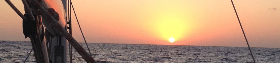


As I write this, we are comfortably anchored at Anse Malendure, on the Western coast of Guadeloupe, after having enjoyed a nice afternoon’s dive with our friends from Wind4Life. A bit of perspective helps.
We left Martinique on a Saturday, with just a couple of days off our general schedule. Why the rush you may say, after all it is a long trip and a rest year. In spite of having skipped Grenada, we still have many areas to see between now and end of April, and this time we had friends coming to Guadeloupe for just a week. We did not want them to linger in a hotel waiting for us.
So off for Dominica, with favorable winds and seas, we were sailing above 10 kn most of the passage between the Islands. On to leeward of Dominica we followed the coast very closely as the winds fall off the cliffs to generate a good breeze. We arrived to Portsmouth with a nice 26kn of breeze and flat seas, “le pied”. The only hiccup was our genoa furler was developing a resistance upon opening and midway, and was too hard to furl bare handed.
Our cruising guide (“A cruising Guide to the Leeward Islands” by Stephen Pavlidis) provides a good outline of the place’s history. The island is inhabited since about 5,000 years. First by Ortoiroids (I need to search who they were, but they left no trace and disappeared) and then the by now familiar Arawaks about 2000 years ago. The less peaceful Caribs arrived thereafter (Dominica hosts the largest Carib community in the Antilles). Cristobal Colon circled Dominica with 17 ships on a Sunday, giving it its present name, but did not land himself. The Island was first colonized in the 1600 by the French, at the same time they were settling in Martinique and Guadeloupe. With the indigenous population pushed inland, the French and British were left free to keep up with their good tradition of battling back and forth, a string that ended in 1763 with the Treaty of Paris giving control to the later. But that did not last, as the French took over again while the British where busy with the American independence. They gave it back in 1783 (Traité de Versailles), only for Napoléon to invade in 1805 and leave only after proper monetary compensation. The British had still to fight off the Maroons (the escaped slaves) from Dominica and neighboring islands, which had united with the French (their former masters) against the British. Very complicated indeed.
Enough history for now, except noting that Dominica became independent in 1978.
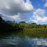
The first impression of Dominica is of a very mountainous place and lush, dense vegetation. It is a prime destination for hikers, bird watchers and nature observers in general, with the government refraining from building resorts and large hotels to preserve the Island, or at least that is the official tune.
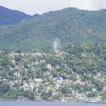
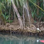
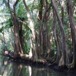
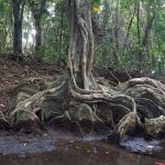
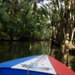
As we were headed to Guadeloupe, our only stop was going to be Prince Rupert Bay – Portsmouth close to the north tip of the island. With the clearance formalities completed, we went for a short stroll to around Portsmouth and in search of Edison, the PAYS (Portsmouth Association of Yacht Security) guide that Youth had recommended. PAYS exists as Portsmouth used to be unsafe for yachts at anchor not so long ago. That evening we arranged up the Indian River, a worthwhile experience as you get deep into the forest, which grows gradually darker and narrower. Then you just need to keep silent and listen to the wild life around you. Edison, as it happens, was at the Bush Bar at the end of the river parcours. After savoring the local Rum drink adequately named “Dynamite” I admitted I was jealous of his bermudas. He replied he bought them at the local mall in Ticino (Fox Town for friends). Imagine that! He is married to a Swiss and visits Ticino every summer, and is also familiar with San Bernardino J. Small world.
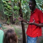
Edison arranged for a tour to the northern half of Dominica for the next day. We never pretended that a day would suffice to visit the Island, but at least we could get a flavor.
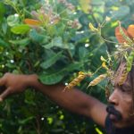
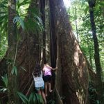
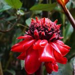
You realize how hilly the island is with the roads’ gradients, and pray that breaks are good for the downhills. Our tour was counter clockwise, starting from the so-called Syndicate region, where we stopped to have a long walk in the forests and admire the vegetation and try to spot the parrots (which were hiding from rain that day). Our guide, both a martial arts master and gardener was extremely knowledgeable about the local trees, fruits and also spices, which we stopped to check, smell and taste. There are plantations scattered in the rain forest, in apparently inaccessible areas. The smaller are for for own consumption, but most are plantations that started in the late 1800s when new crops where introduced on the Island, such as coffee, limes, banana, etc.
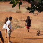
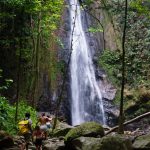
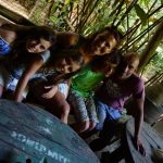
From there, we headed to the falls that bear the same name. This time the fall itself was beautiful, and the pool beneath as well. Only the girls dared the bath, as the day was hazy and the water spray very cool. For some reason females are stronger under those circumstances.
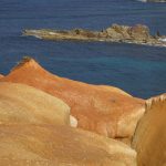
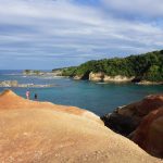
A long drive took us North to the Calibishe village, where we stopped for a lunch, with views on the Atlantic Ocean and Red Rock, a rocky formation of volcanic origin which was going to be our next stop. A completely flat Ocean should have raised some suspicion as to the bizarre situation that was building up in the meantime around Keraban….
In between however we also visited a small chocolate manufacture established by a French family, where we were guided through the traditional process of making this magic stuff. Funny the Swiss crew learned it in Dominica.
The drive was taking longer than I had anticipated, with some very, very steep roads. A sixth sense told us to cut it short and start heading to Portsmouth. Indeed, we realized something was not usual when we got a view of the bay from uphill. The water was brownish and, although we were far to spot the boats movements, their layout at anchor had drastically changed.
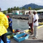
A low pressure farther North had sucked all the strength from the easterly trades, and brought a NW swell into the bay, which explained why the Atlantic shore looked as flat as the lake of Lugano. This is the kind of situation the GRIB data will not show with accuracy, and you need to listen to local radio or fishermen’s advice, which we had not. Once we got to the bay it was a mess, a good 1-1.5m of very short chop, boats facing west and some threateningly close to shore or to their neighbor. Keraban was fundamentally safe, with 50m of chain on 6m depth, far from shore and no neighbors. Luckily that morning we had been picked up by a fisherman’s boat to go onshore, as it would have been foolhardy to attempt a reentry with our tender and 3 kids. Climbing onboard was by far the most perilous moment in the last half year: The stern was slamming hard on the water, gobbling up the dinghy which was short leashed with a security line, but still the only platform between our transport and Keraban to attempt getting onboard. The kids somehow managed through a relative quiet and without panic, Isa got the worst part and was stuck in the dinghy with the boat slamming dangerously nearby for a very long couple of minutes. In all this, it was good we had returned during daylight.
Once inside, we soon realized the night was going to be very bouncy and was going to need an anchor watch. The equally unappealing choice was to leave the bay at night and head towards Guadeloupe, and moderate our speed to avoid a night arrival. As two yachts banged into each other behind us, we definitely made up our minds. The tender was an issue as there was no way to bring onboard, and it would have to be towed to attempt a recovery at large with quieter seas.
We left at around 9 PM, slowly proceeding under engine, towing the tender (with the engine on it and the prop in the water…). Even out of the bay the seas were too large to attempt a recovery, so we set sail and headed towards Guadeloupe with our dinghy hanging out there. As we were tired, a plan B was to attempt an anchorage at Marie Galante or Les Saintes, around halfway some 20 miles ahead, which would have allowed for a few hours of sleep. We opted for the 2nd as Marie Galante, although very broad and free of dangers, is dotted with fisherman’s pots which are impossible to spot at night. We had spent no more than 10 minutes below decks looking at the charts, but as I returned on deck it was all very quiet….the noise of the dinghy dragging water was absent, and indeed it had parted company. It was close to midnight, we hit the MOB button and started a search tracing back our route and trying to take into account time lapse and current. After half hour and no luck, we abandoned. We did not try a structured search pattern as we were both tired and still had a couple of hours of sailing ahead and an anchorage at night on unknown waters. We did consider a notice on channel 16 to warn sailors of a drifting hazard, but after consideration we opted not to as the risk of confusion with a more serious situation was significant and there was strictly no traffic in the area.
We chose the safe option to get into the Saintes Archipel, i.e. from the channel south of Guadeloupe and then rounding Cabrits from West. This added a good 7 miles, but was free of dangers. Once nearby Cabrits we realized two things. There was no obvious anchorage as the area had been fully occupied by buoys, and calibrating the distance for an anchorage between the many mooring lights in a dark, moonless night was beyond my capabilities. We tried behind Pain de Sucre, with the same results and at about 2.30 AM we decided the best option was Ilet du Gosier, 3nm East of Pointe à Pitre, which with 15 miles to go and a nice breeze meant getting there in the early morning. Isa secured the first watch allowing me to sleep a good 2 hours, enough to clear the haze for a safe anchorage behind Gosier. The prize is having a beer at 6 AM and then laying on your bed knowing you will sleep as the waters are quiet and the anchor is properly set. Repairs (the genoa furler was no longer furling without applying strong efforts) and replacing the dinghy & engine are for maniana…./21